SKYHAUL ADA

Precision Aerial Data Solutions That Empower Your Projects
Based in Cincinnati, Ohio, SKYHAUL Aerial Data Acquisition Group delivers cutting-edge aerial data services, including LiDAR, Photogrammetry, and Thermal Inspections. We support industries from mining and construction to infrastructure inspections—providing reliable, actionable insights.
Our team of expert pilots is committed to excellence and safety:
- FAA Part 107 Certified
- TWIC Approved
- OSHA 10 & FEMA Trained
- Level 1 UAS Thermography Certified
With SKYHAUL, you gain a trusted partner dedicated to meeting strict regulatory standards and elevating your project outcomes through precision data collection.
Solutions We Provide

LiDAR Scanning
High-Precision 3D Mapping:
Experience centimeter-level accuracy for terrain analysis and infrastructure planning. Our state-of-the-art LiDAR technology penetrates vegetation to deliver reliable data in even the most challenging environments.
Photogrammetry
Detailed Aerial Imagery:
Capture high-resolution images to create precise orthomosaic maps and 3D models—ideal for monitoring construction progress, land surveying, and urban planning. Benefit from fast, accurate outputs that support informed decision-making.
Thermal Inspections
Advanced Thermal Analysis:
Leverage cutting-edge thermal sensors to inspect solar farms, roofs, power lines, and other critical infrastructure. Our thermal imaging identifies hidden defects early, helping prevent costly failures and ensuring optimal maintenance.
Data Deliverables and Processing
Customizable, Actionable Data:
Receive a range of deliverables—ranging from LiDAR point clouds and orthomosaic maps to 3D models and contour maps—tailored to your project needs. Our advanced processing techniques format the data perfectly for immediate integration in engineering, construction, or asset management projects.
introducing The SKYHAUL ADA VISTA app
Our unique approach to client data and asset management
We have developed our SKYHAUL ADA VISTA app to make tracking your asset maintenance, reports, job-site progression, and visualizing your 3D models, all in one secure location. You no longer need to pay for hosting and purchase expensive software bundles and train your team to view your 3D assets, pull measurements, etc., like with all other service providers … SKYHAUL ADA has done all of that for you in our intuitive, easy to learn and share application. Our ADA Vista app is a game changer in the industry.
As a client, you will receive a secure login giving you access to all of your projects, models and reports in one location. This allows you to easily share links to your 3D visual models and reports with the members of your team. They can view it when they need it and where they need it 24/7. Convenience, precision, and security is the name of the game.
We encourage you to take a moment to explore our samples. If you have any questions, reach out to us! We’re here to help!

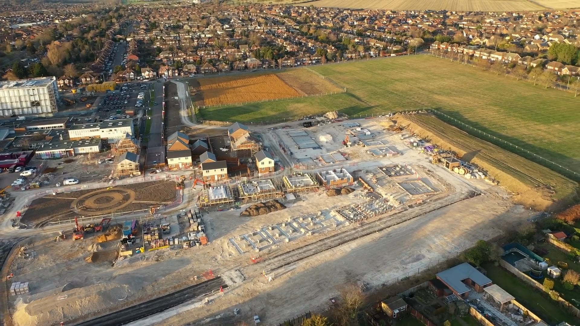
JOB‑SITE PROGRESSION
JOB‑SITE PROGRESSION—PLUS ON‑DEMAND VOLUMETRICS
Steel up, earth moved, schedule verified—every seven days.
Our FAA‑certified crews fly the same precise grid each week, stitching high‑resolution orthomosaics and 3‑D meshes your supers drop straight onto plans before the next OAC call. No survey stamp, no guesswork—just crystal‑clear proof that crews and cash‑flow stay on target.
And because every flight captures a dense point cloud, we can pull stock‑pile volumes and cut/fill numbers from the very same dataset—fast, accurate, and without an extra mobilization.
- Orthomosaic + 3‑D Mesh
Geo‑referenced TIFF, OBJ/LAZ, and annotated PDFs, auto‑synced to your BIM 360 or Procore folder.
- Slide‑Bar “Then vs Now” Viewer
Spot clashes, delays, or out‑of‑tolerance pours in seconds—perfect ammo for RFIs and pay‑apps.
- Drone‑Eye Safety Snapshots
Highlight fresh openings, material stockpiles, and shifting site access so the safety crew can act before toolbox talks.
- Stock‑Pile Volumes & Cut / Fill Heatmaps
Derived from the weekly cloud—color‑coded PDF overlay .
- LiDAR‑Ready Upgrade (optional)
Need centimeter‑grade accuracy for payment or compliance? We bolt on the survey‑grade sensor and accurate deliver point clouds.
- Lock‑In Scheduling
Reserve weekly or bi‑weekly flights for the life of the project; crews arrive rain‑clear as soon as FAA rules allow.